


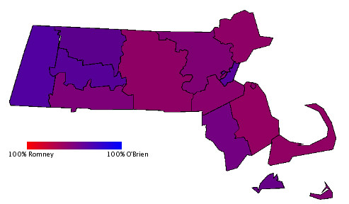
As a follow-up to my previous post with a county-level map of the 2002 gubernatorial election, I took the state's city and town map and did the same thing:
Click on the picture for a bigger version. I think from this map, it's clear to see where O'Brien's problems were. Romney won almost all of the suburbs outside of 128. In Worcester county, O'Brien only won the city of Worcester, and barely at that. In Plymouth county, O'Brien was only able to win a majority in Brockton. It's clear, if it wasn't already, that winning big margins in the cities is not enough for Democrats to win the governorship. If the Democrats are serious about beating Romney, they will have to not only hold the cities, but also make inroads into the suburbs and central Mass. There is no reason that the Democrats can't do well in Middlesex county, if only though GOTV efforts in the southern part of the county (Cambridge, Somerville, Newton, Watertown and Arlington). O'Brien also only won Lowell by a handful of votes whereas Kerry won the city by a margin of two to one.
While Plymouth county is trending more Republican recently, if the Democrats can be competitive in Worcester county, win Middlesex County and hold the rest of the state to 2002 levels, they should be successful. Some of this will be a function of the candidate -- Can Reilly or Patrick appeal to voters in these areas? Reilly's geographical base is in Middlesex County. Patrick's is harder to judge given his status as an outsider, but he should at least be able to win his home of Milton (which went to Romney in '02), something that I would not expect Reilly to be able to do. No matter who the candidate is, however, the state Democrats will have to organize in the suburbs if they want to convince voters that it's worth it for them to abandon their preference for divided government and finally elect a Democratic governor.
Showing posts with label Map. Show all posts
Showing posts with label Map. Show all posts
Thursday, February 17, 2005
Purple Massachusetts II
Wednesday, February 09, 2005
Purple Massachusetts
Just for fun, I took a crude map of Massachusetts and drew in the 2002 election returns in a style similar to the Purple America map that was floating around after the November election. I wanted to have a clear picture of where the Democrats where weak that year. It turns out that they were weak pretty much everywhere east of Springfield, apart from Boston. Take a look:
Romney vs. O'Brien 2002
Click on the map for a bigger version of the same. From the map, it's clear that O'Brien was strong in Berkshire, Hampshire and Franklin counties (where nobody lives) as well as Suffolk county (which is bigger than the other three combined). Romney was strongest in Worcester, Plymouth, Essex, Norfolk and Barnstable, though he won all the rest of Massachusetts as well.
Compare that showing with the 2004 election:
Bush vs. Kerry 2004

Now, as the UMass poll indicated, the people of Massachusetts draw a distiction between who they want as President and who they want as Governor. Still, the contrast is stark. Kerry won every county, but you can still see the purple areas of this map correspond to the reddest areas of the 2002 map. This suggests to me the ceiling that any Democratic candidate for office can be expected to reach in Massachusetts when running against a credible challenger. If the Democrats can leverage their Kerry turnout organization, they could overwhelm Romney no matter who the candidate is. Of course, getting every Kerry voter to a) come out in '06 and b) vote for the Democrat is a bit of wishful thinking. Even so, support for Democrats in general is high in Massachusetts and if the party gives the voters a compelling reason to discard their preference for divided government, Romney could be in trouble.
Subscribe to:
Comment Feed (RSS)